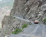
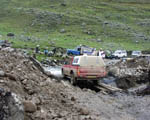
Mitzi bemused the locals on the River Road near Mayocc
The granddaddy of landslips - open again in two weeks, they tell us
|
Mitzi bemused the locals on the River Road near Mayocc |
The granddaddy of landslips - open again in two weeks, they tell us |
Day 35 - Thursday 24 February
Another slow day, but much more satisfying. Yesterday, we spotted a sign saying that the road had been recently improved over the 114 km to Lircay, so we decide to try it as an alternative.
It has turned out to be totally brilliant: a lovely smooth gravel road twisting and turning through superb countryside of neatly tended mountain farms and charming little lost towns, rising up to over 15,000 ft (according to our not-very-trusty Magellan GPS).
Jingers, himself a country boy, cannot get over the steepness of land that is cultivated here. Some of the little plots are high up the mountain sides, at angles much steeper than 45 degrees.
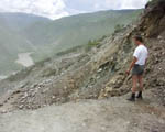
The bad news is that the last few nights' rain have again caused havoc. As early starters, we have had to shift newly fallen boulders and pioneer ploughing a channel through the tongues of mud.
The road has only been open two months, and not all the bridge works are finished. Another river torrent has stopped everything except the big trucks, but Jingers gets Mitzi across.
Still beautifully surfaced in between the rain damage, the road climbed to over 15,000 ft, where llamas graze on coarse grass in a landscape reminiscent of Wales. Up here, the road builders had cut a temporary channel to divert a mountain torrent to enable them to build a new bridge; we waited an hour or so, watching in fascination as they created a makeshift bridge across the bypass channel by building up abutments of rocks culled from the landscape and lashing poles together.
We made it to Lircay - a pleasant little town - about four hours later than planned (moral: in the Andes, don't make plans, especially in the rainy season).
I have long been fascinated by a passing reference in the South American Handbook - an excellent guide which all intending participants on the Inca Trail should buy - to 'the highest driveable pass in the world', near Huachocolpa. Despite the late hour, we start out from Lircay to find it, but after just a few kilometres we are confronted by a roaring river that daunts even Jingers.
Instead, we have taken the direct road from Lircay to Huancavalica, which turns out to be another good section: reasonably surfaced, open and sweeping, through high rolling pampas. We share some of our picnic lunch with a local character who is carrying his harp down into Lircay for repair; he embraces us with smelly affection.
It was dark and damp when we got to Huancavelica - just like the main hotel. Still, at least we got another good meal in a local restaurant. More rain.
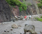 Jingers and German clear the road |
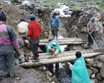 Road workers put the finishing touches to the bridge across their temporary river diversion channel |
 Mitzi is first across - Jingers would have preferred a smaller gap in the middle |
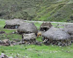 'Desirable thatched country residence, of local stone, with full range of outbuildings. Ideal for equestrian use. Superb riverside setting.' |
Day 36 - Friday 25 February
I woke up early and planned the day. We will drive back to Lircay (noting the road as a regularity section), then go over the mysterious 'highest driveable road', then come back through Huancavelica to Huancayo, our goal of two days ago. If we have time, we will then backtrack to the big slide.
Some hopes. The trip meter decides to play up, which delays us for a couple of hours.
On my last visit to Lima, I invested in a set of 1:250,000 maps, obtainable only by visiting the Instituto Geográfico Militar. These are now proving their worth, as we find a loop road around the torrent which stopped us yesterday. This is incredibly rough, but does bring us to the other side. The water is fiercer than ever, but at least we are on the correct side now.
The road up the valley to Huachocolpa is a superb 4x4 drive, sometimes through eucalyptus groves along the floor and sometimes climbing up the sides (more drops, I'm afraid). We finally emerge among brightly coloured sediment flows to this high little mining town, complete with a decent sized bull ring.
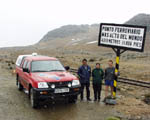
Now the drama really begins. The road out of town zigzags dizzily up and up through a series of great mines, in places clinging precipitously to the mountain side. Big ore trucks gingerly pick their way up - God knows what happens if two of them meet on a narrow ledge. We climb up above the snow line, and finally reach a little sign which says 5,059 metres - that's 16,590 feet.
I don't believe that this is in fact the world's highest driveable pass - Jingers says he has been to over 17,000 ft in the Himalayas - but it probably is the highest in the Americas. Anyway, a group picture is definitely called for. We restore the sign a little, and leave an Inca Trail sticker on it.
Shortly after, we rejoin the main road across the high Altiplano back to Huancavelica. It's getting dark by then, but we have to be in Lima tomorrow so we press on. We finally arrived at Huancayo, totally exhausted, at about 1.00 a.m., Jingers having performed wonders at the wheel.
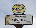 The highest road sign, complete with Inca Trail sticker |
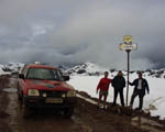 The Team (Mitzi, Jingers, Jo and German) at 5,000 metres |
Day 37 - Saturday 26 February
Lima at last.
We have decided that it will not be practicable to take the rally from Ayacucho to Lima in one day, especially as we have found such terrific sections on longer routes, so we spent the morning 'sorting' Huancayo as a night halt.
Then it's 385 km of spectacular asphalt back down to the rally's Lima hotel. La Oroya is a smoke-belching industrial town. Soon after, we climb to the Abra Anticona, also known as Ticlio, which at 4,818 metres (15,806 ft) I believe to be the world's highest asphalt main road, alongside what a sign (but not the Guinness Book of Records) claims as the world's highest railway line. Time for more group pictures.
It is now literally downhill for 130 km - cyclists go up by train to coast back. Jo is delighted by our chosen resort village hotel of El Pueblo, well outside the smog zone and a super place to relax for our Lima rest day. Sadly she flies home early tomorrow.
At least she will be able to carry back this Log and our pictures, as I have not yet come to grips with South American technology sufficiently to send back the daily e-mails we had planned.
 Mitzi and crew at the world's highest railway line (it says here)... |
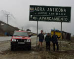 ...and the world's highest asphalt main road (I think) |
Next Instalment