IN SEARCH OF THE INCA TRAIL
Being John Brown's Route Survey log
EPISODE NINE: Days 49 to 54 (Arica to Alberdi)
Day 49 - Thursday 9 March
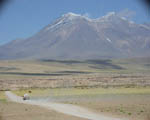
Today was a long day spent wholly on the asphalt ribbons which traverse the great dry landscapes of the Atacama Desert. South of Arica, the Panamericana rises to about 5,000 ft, then plummets into a couple of vast deep quebradas, or steep-sided valleys.
This is one of the world's most famous mining areas, and is dotted with ghost nitrate miners' townships, including a couple which are preserved as museums. We then followed the newly asphalted and spectacular coast road south from Iquique - pronounced Eekeekay, which makes a nonsense of the limerick - to Tocopilla, where I was taken with the local golf course, as well as the electric railway which still carries goods and people vertiginously down from the high plain to the sea.
Then back to the endlessly straight asphalt eastwards to Chuquicamata and Calama. The Park Hotel is surprisingly luxurious, expensive and busy - but this is prosperous mining country and the clientèle consists of engineers and businessmen.
The Pisco Sours are lousy again. Clearly, the change in national culture when we crossed the frontier was abrupt and total. We decide not to try again.
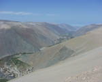
The Panamericana (just visible on the right) drops some 5,000 ft down from the Atacama Desert plateau to the fertile Quebrada de Camarones; you can just see the Pacific Ocean in the distance
|
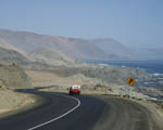
The spectacular coast road south of Iquique
|
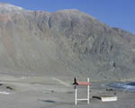
The 16th hole of Tocopilla Golf Club - tee in the box on the right, green (brown?) in front of the rocks to the left
|
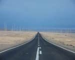
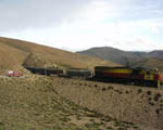
The road eastwards to Chuquicamata
|
Day 50 - Friday 10 March
We have now been on the road for the same number of days as the whole rally... and we're not halfway yet.
Spent the day sorting Calama and Chuqicamata. Again, good welcome from municipality and local motor club. Chile is made so much easier by the series of three splendid Turistel guidebooks, full of excellent full colour maps and town plans, produced annually under the sponsorship of the national telephone company.
Calama is a pleasant enough desert town, but Chuqui (as it's called) is something else: an undistinguished company township belonging to Chile's national copper mining corporation, with the largest opencast copper mine in the world. If Llantrisant is the hole with the Mint, Chuqui is the hole with the hole.
But like the Royal Mint at Llantrisant, it makes money. The copper mined here accounts for 40% of Chile's export earnings. No wonder the bar prices are high at the Park Hotel.
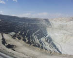
The hole at Chuquicamata copper mine
|
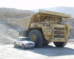
Dumper truck and friend, Chuqui; this one is a museum exhibit, being too small for current requirements
|
Day 51 - Saturday 11 March
Left well before dawn, but back in town three hours later. We'd planned to take a gravel route to San Pedro de Atacama via the geysers at Tatio, but have now abandoned this plan because (a) the roads are too poor and (b) we've been told that you have to get to the thermal area by 07:00 at the latest. As this means getting up at 03:00, we didn't think it would be too popular. Those who are very keen can go off their own bat - the roads are at least well signposted.
We then took the easy tarred option to San Pedro, a delightful little town against a backdrop of great snow-capped volcanic peaks. We will recommend a pause here.
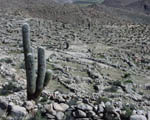
There is much more asphalt than we had expected on the route towards the Paso Sico, and then the gravel is smooth and fast, so we make good time. The scenery becomes more and more stunning, on a truly epic scale. We see a sign towards a couple of loops, note that it is a loop which rejoins the main road, and take it, to discover a wondrous 26km 4x4 section past deep blue soda lakes where flamingos flock in season, in front of great snow-capped mountains.
The road rises to 14,600 ft on our Magellan, before we drop slightly to cross into Argentina at the Paso Sico, one of the world's highest and most remote frontier posts. The road remains excellent gravel, much of it criss-crossed by one of the world's highest working railways (care at level crossings!) all the way to the rather charmless village of San Antonio de los Cobres (and the first fuel on the route since we left Calama 444 km back). We are staying in a basic but sadly not cheap Hosteria. We haven't dared ask for Pisco Sours, but the beer is fine.
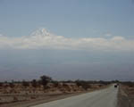
Volcano towering over San Pedro de Atacama
|
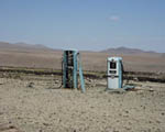
The only fuel pumps on the route in the 444 km between Calama and San Antonio de los Cobres
|
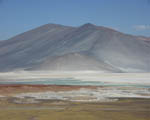
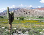
Miscanti, a mountain on the 4x4 lakes loop
|
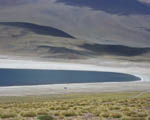
Laguna de Miscanti, one of the lakes on the 4x4 loop - that's a blue pick-up on the shore
|
Mitzi is dwarfed by the scenery at Tuyajto soda lake
|
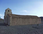
Old church at Cauchan, after crossing into Argentina |
|
Don't assume there won't be a train emerging from a cleft in the hillside at a remote level crossing!
|
|
Day 52 - Sunday 12 March
Jingers had a near-orgasm before we left San Antonio: we spotted a Ford Model A in the police compound, which turns out to be a rare 1930 Victoria model which he covets; this one is even rarer because it has right hand drive. He reminds me that the Argentinians drove on the left until 1940 - some still do. He plots how to get it out of the country - not easy as there are restrictions on the export of old cars.
Half the road down to Salta is now asphalted, and the work is proceeding apace. It passes through the Quebrada de Toro, a beautiful fertile valley which becomes a narrow gorge closer to Salta. We see a sign for the Ruinas de Santa Rosa de Tastíl, and follow a gravel road which zigzags up the hillside, not knowing what to expect, to find the extensive remains of a pre-Inca civilisation.
Salta is a most beautiful city, with a splendid colonial main square. It is made even finer by the wonderful welcome we got tonight from Alejandro and Ricardo, two classic car and 4x4 enthusiasts, who take us out for a great parilla, or mixed grill.
Santa Rosa de Tastil pre-Inca city
|
Quebrada de Toro
|
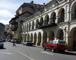
Colonial houses, Plaza de Armas, Salta
|
Day 53 - Monday 13 March
A very good day in Salta, meeting the municipality, inspecting hotels and sorting routes into and out of the city. Alejandro generously devotes most of his day to us, so we eat well too. Ricardo arranged for us to be personally received by the Governor of Salta Province, who turns out to be another classic car enthusiast, with a fine 1930s Ford V8.
I find a set of the six YPF guides, sponsored by the leading Argentine petrol company; they are produced by the same editorial team as the Turistel ones for Chile, and are just as good. I also find the excellent new Firestone road atlas, which is particularly good at giving up to date information on asphalted roads.
Day 54 - Tuesday 14 March
Argentine place names can be deceptive. Towns like San Salvador de Jujuy and San Miguel de Tucumán are usually just known by their last word, which can make it tricky to find them in a directory. Catamarca, where we should have been tonight, is an extreme case of this. Its full name is San Fernando del Valle de Catamarca, but most people just use the abbreviated version.
I had a real problem finding the country's main ski resort, Bariloche, in my airline guide. It's not listed under B, so knowing its full name is San Carlos de Bariloche, I looked under 'San' - no joy there either. I then looked under plain 'S', but drew another blank. I finally found that their non-literate computer had listed it as 'S. C. de Bariloche', under 'Sc...'!
Here you get used to streets which are famous dates, but they also like to call towns after celebrated people - not just the surname, but the full name and title. The little town where we are staying tonight is called J B Alberdi; we have got to know the people so well (the beer flowed copiously) that we are now on first name terms, and call the place 'Juan'.
The military are especially well represented. The Inca Trail is spending one night at Commodore Rivadavia's place, and I was of course pleased to make the acquaintance of Admiral Brown. We had come across towns called Gral M de Güemes, after a famous general, and Cnel Moldes, after a colonel, but near here we were surprised to see signs to a Cap Cáceres, a Sargento Moya and even a plain Soldado Maldonado.
Jingers and I asked whether it was more prestigious to live in a general than a colonel, and whether a town can gain promotion to a higher rank if it gets more important. It would never do to have a mere private as a capital city (although I seem to remember that the ruler of Ghana was refreshingly once a mere Flight Lieutenant Jerry Rawlings - did he still take orders from his squadron leader? Perhaps this is romantic nonsense, given that the horrific Idi Amin promoted himself directly from Sergeant Major to Field Marshalissimo).
We came to be here, in a friendly but basic hotel, because the rains have struck again. We spent too much time checking out more hotels in Salta and visiting the super little race circuit there to design a lap consistency test. We didn't finally get going until noon, at first in bright sunshine through the amazing Quebrada de Cafayate, a sandstone gorge with some curious rock formations including the Anfiteatro, more a giant chimney than an arena.
Soon after, though, it got foggy and wet and dark, and we started coming across evidence of the very serious flooding that had struck the Tucumán area a couple of days before. We found a way round one closed road, but after a couple of hours we were stopped on the main road by a policeman. He told us that two bridges were down before Catamarca, so we backtracked, getting reconciled to spending a hungry night in Mitzi.
But when we got to Alberdi - sorry, to Juan - the steamy windows of a café attached to a filling station were lit. The place was full of local young people hanging out, and other refugees from the vast electric storm that was raging outside, punctuating the activities with great thunderclaps and the odd power cut. It was a perfect Hollywood B-movie set.
We dined well on Milanese - steak in breadcrumbs - and jokingly asked where the hotel was. A large chunk of the party immediately decamped with us to it, and were very disappointed when finally we took to our beds. It's hot, the window's open, and I've donated several pints of blood to the mosquitoes. I hope they die of alcohol poisoning.
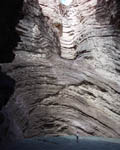
Jingers on stage in the Anfiteatro, in the Quebrada de Cafayate
|
Next: Alberdi to Santiago